In Stock
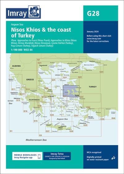
G28 Nisos Khios & the Coast of Turkey
Sheet map, folded
€28.74
Collect 86 Reward Points
- Free Delivery from
- This Book Is Available Online Only
- Book Synopsis
- Plans included:Approaches to Psará (Nìsos Psará) (1:15,000)Approaches to Khìos (Nìsos Khìos) (1:20,000)Órmos Mandráki (Nìsos Oinoússa) (1:8,000)Çesme Körfezi (Turkey) (1:18,000)Foça Limani (Turkey) (1:20,000)Sigaçik Limani (Turkey) (1:18,000)Imray-Tetra charts for the Ionian and Aegean are widely acknowledged as the best available for the cruising sailor. They combine the latest official survey data with first-hand information gathered by Rod and Lucinda Heikell. The chart is designed to be used alongside Imray pilot guides of the area. Like all Imray charts, they are printed on water resistant Pretex paper for durability, and they include many anchorages, facilities and inlets not included on official charts.This edition includes the latest official data combined with additional information sourced from Imray's network to make it ideal for small craft. It includes the latest official bathymetric surveys. There has been general updating throughout.
- Product Details
-
- ISBN
- 9781786790156
- Format
- Sheet map, folded
- Publisher
- Imray, Laurie, Norie & Wilson, (30 January 2024)
- Number of Pages
- 2
- Weight
- 180 grams
- Language
- English
- Dimensions
- 297 x 210 x 8 mm
- Categories: