-
BROWSE 1000s OF BOOKS IN STOCK
-
FREE DELIVERY ON ORDERS OVER €10
-
PRE-ORDER OBSESSED BY JOHNNY SEXTON
World Executive, Enlarged &, Tubed
Other Digital
Categories:
World atlases / world maps
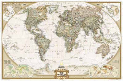
The most up-to-date executive world map from the cartographers at National Geographic, in an enlarged size. This map features the Winkel Tripel projection to reduce distortion of land masses as they near the poles. Features an antique-style colour palette for a more upscale look. Separate insets show the North and South Polar Regions, world vegetation and land use, and world population density. Scale 1:22,445,000. Tubed. 185 x 122 cm.
€50.74

152 Reward Points
In stock online
Extended Range: Delivery in 2-3 working days
Extended Range: Delivery in 2-3 working days
Free Delivery on this item
Any purchases for more than €10 are eligible for free delivery anywhere in the UK or Ireland!
The most up-to-date executive world map from the cartographers at National Geographic, in an enlarged size. This map features the Winkel Tripel projection to reduce distortion of land masses as they near the poles. Features an antique-style colour palette for a more upscale look. Separate insets show the North and South Polar Regions, world vegetation and land use, and world population density. Scale 1:22,445,000. Tubed. 185 x 122 cm.
152 Reward Points
Any purchases for more than €10 are eligible for free delivery anywhere in the UK or Ireland!
€50.74
152 Reward Points
Any purchases for more than €10 are eligible for free delivery anywhere in the UK or Ireland!
Categories:
World atlases / world maps
Product Description
The most up-to-date executive world map from the cartographers at National Geographic, in an enlarged size. This map features the Winkel Tripel projection to reduce distortion of land masses as they near the poles. Features an antique-style colour palette for a more upscale look. Separate insets show the North and South Polar Regions, world vegetation and land use, and world population density. Scale 1:22,445,000. Tubed. 185 x 122 cm.
Product Details
ISBN9780792293170
FormatOther Digital
PublisherNATIONAL GEOGRAPHIC (02 August. 2012)
No. of Pages1
Weight437
Language English
Dimensions 1270 x 56 x 22